
| |
South coast climate |
The climate of the south coast is generally determined by the annual north-south migration of semi-permanent global pressure and wind belts. |
|
Summer

|
In summer a region of high pressure cells moves southwards to a latitude of around 40 degrees south. Due to the anticlockwise rotation of air around the cells, this results in westerly winds well to the south of Australia and generally easterly winds along the south coast. This tendency is accentuated by the oblong shape of the cells which have their long axis east-west. The zone between the high pressure cells is occupied by a trough of low pressure which is the northerly extension of a low-pressure cell well to the south. This trough often contains a weak cold front which brings cloud to the western south coast but not very much rain, except for drizzle in the on-shore southerly winds which follow the passing of the front.
A trough can also develop from the north, usually aligned with the west coast and resulting in more northerly winds to the east of the trough. The air in these winds, having travelled over the hot dry land of central Australia, can result in short periods of very high temperatures on the south coast. If moist air from the north west is drawn into the trough, thunderstorms can occur on its eastern edge and bring sudden summer rain to the south coast region, especially in the east. In coastal areas the differential temperatures between the land and the ocean can result in a local sea breeze. Since it is driven by the heating effect of the sun, it normally does not start until about midday and ceases once the sun goes down. |
|
Winter
|
The high pressure systems move northward in winter with their axis lying at about the same level as Perth and therefore well above the south coast region. As a result the region lies in a belt of cool moist westerly winds, containing frequent cold fronts which provide the lift required to condense the moisture in the air and create rain. The air movement behind the fronts tends to be from the south resulting in the cold winter gales common to the south coast. The more northerly location of the eastern part of the south coast region means that it is drier than the west, since the fronts are weaker on their northern extent, and the westerly winds have a longer passage over land to reach this area.
Since much of the rainfall in the region results from the effects of constant and large scale global air movement, it is very reliable by Australian and world standards. Within the region, however, there is a tendency for rainfall to become less reliable from west to east. |
South coast geology
|
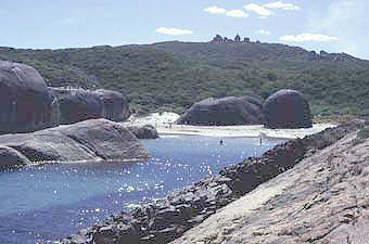 The geology of the south coast region can be traced back to over 1000 million years ago, when what is now the southern edge of Australia was pressed up against a piece of Antarctica. As the western two-thirds of Australia were being welded into a stable block which persists to the present day, the Australia-Antarctica boundary was being compressed and the pre-existing rocks were deformed by heat and pressure. Granites under the earth's surface, originally crystallized from molten rock, were transformed into gneisses which now underly much of the region and are exposed in the Porongurup Ranges and in places along the coast. Sand, silt and clay sediments were transformed into the metamorphic rocks which can now be seen in the Stirling Ranges and at Mount Barren.
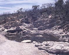
As a result of further crustal movement, by 600 million years ago Australia and Antarctica became part of the huge supercontinent of Pangaea, which also included pieces of all the present continents. Over the next 400 million years, while Australia gained its current eastern third and Pangaea separated into Gondwana and Laurasia, the connection between Australia and Antarctica remained. During this time, the first land plants and animals appeared and evolved into all the major groups which still exist today. About 120 million years ago changes were initiated which had major consequences for the geology of the south coast region. Starting in the west, Australia and Antarctica began to separate. As they moved apart and the sea moved into this gap, the new continental margin sagged, creating the generally south facing slope characteristic of the region today. On the hinge, the Stirling Ranges rose above the surrounding land. By 60 million years ago, the last connection between the two continents, south of Tasmania, was broken. The region underwent periods of erosion and deposition until 40 million years ago, when higher sea levels saw most of the region covered by the sea and marine sediments were laid down. Another southward tilting event 30 million years ago created the Ravensthorpe Ramp, and with lowered sea levels led to the formation of many of the southward flowing rivers that are characteristic of the region now. The far east of the region suffered another incursion by the sea about 20 million years ago; the retreat of the sea left the relatively flat areas of inland drainage which still exist east of Esperance today. Percolation of rain water through coastal dunes, dissolving shell material and reprecipitating it as calcite, has cemented sand dunes to form limestone beds near the coast. Winds blowing from the sea have carried beach sand and shell fragments inland to create dune fields in places along the coast. Ancient glaciation and recent chemical weathering by rain water and erosion by water and wind have sculpted the various rock formations into their present forms: rounded, gentle granite or gneiss hills, steep quartzite cliffs in the Stirlings, undulating plains and incised river valleys in Tertiary sediments and dune fields of recent windblown sands. |
Vegetation and land
|
 The natural vegetation of the south coast varies from forest in the west through various types of scrub and heathland to desert in the east. The area is renowned for its floral diversity, with the Fitzgerald River National Park recognised as an international bisophere reserve under UNESCO's Man and the Biosphere Program. A reasonable proportion of the near-coastal areas has never been cleared, and now is mostly preserved in national parks and other reserves.
The lower rainfall, poor drainage and low permeability of the soils of much of the inland areas of the region has resulted in salt blown in from the sea accumulating in the groundwater. In the east of the region, salt lakes occur in depressions where the water table intersects the ground surface, and many of the rivers are naturally salty. Farming activity in general is located inland from the coast, with the main land uses being cropping and grazing (mostly sheep). Where deep-rooted native vegetation has been cleared and replaced by shallow-rooted crops and pastures, the increased recharge has allowed the water table to rise, bringing the salts closer to the surface. This has increased the salinity of many rivers, and in some areas the salty groundwater reaches close to the land surface, resulting in salt scalds. The resulting death of almost all vegetation acts as a positive feedback to the process, with even higher water tables and a subsequent increase in the area of salt-affected land. |
